i-Boating:Denmark Marine Maps 95.0
Paid Version
Publisher Description
GPS Marine Charts App offers access to charts covering Denmark. First marine GPS app to have route assistance with Voice Prompts for marine navigation. You can create new boating routes or import existing GPX/KML routes. It supports Nautical Charts course up orientation. Includes Tide & Currents prediction.
►FEATURES
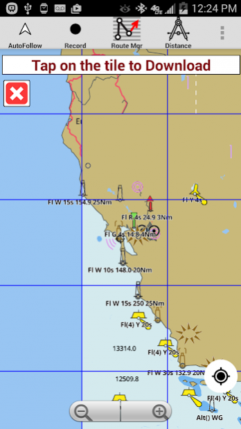
√ Download Beautiful & detailed Hardware/GPU accelerated vector charts (text stays upright on rotation)
√ Query details of Maritime object (Buoy, Lights, Obstruction etc).
√ Custom depth(Ft/Fathom/Meter) & distance units (km/mi/NM)
√ Custom Shallow Depth.
√ Record tracks, Autofollow with real-time track overlay & predicted path vector.
√ Voice Prompts for marine navigation (requires GPS )
√ 1ft / 3ft depth contour maps for anglers for selected lake maps. Useful for fishing/trolling(freshwater/saltwater).
√ Supports GPX/KML for boating route editing/import.
√ Tide & Currents.
√ Seamless chart quilting. Map details from Coastal, Approaches,Harbour, Inland Encs(rivers), and general ENC (Electronic Marine Charts) are automatically mapped to correct zoomlevel
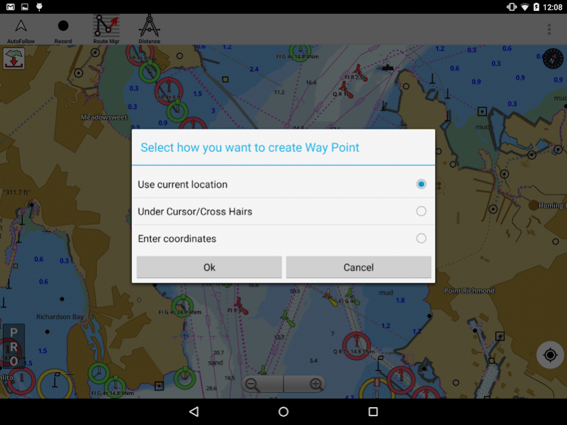
√ Enter / import Waypoints.
► MAPS
Get all the details that you find in your chartplotters!
Denmark((derived from KMS/GST (Kort & Matrikelstyrensen / Geodatastyrelsen
(GST)data))
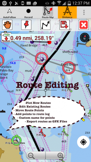
►ROUTE MANAGEMENT / TRIP PLANNING
√ Create New /Edit Routes
√ Reverse Routes
√ Enter,Move, Add, Delete, Rename Waypoints
√ Import GPX, KML & KMZ files
√ Plot/Edit Routes
√ Share/Export Routes, Tracks & Markers
►GPS FEATURES
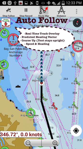
√ Auto Follow
* Real Time Track Overlay
* Predicted Path Vector
* Course Up (Text stays upright)
* Speed & Heading
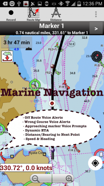
√ Route Assistance With Voice Prompts
* Prompts when approaching a boating route marker
* Continous distance & ETA updates
* Alerts when sailing/boating off route
* Alerts when boating in wrong direction
√ Record Tracks
►TIDE & CURRENTS
* For US, Canada, UK,Germany&New Zealand
* High/Low Tides
* Tidal Current Prediction
* Active Current Stations
►CHARTS INCLUDED
√Aabenraa Fjord
√Aalborg
√Aalborg Bugt
√Als Sund og Sønderborg Fjord
Árhus Bugt
Árhus Havn
√Bælthavet
√Bornholmsgat
√Danmark med omgivende farvande
√Danmark. Søgrænser
√Fakse Bugt og Præstø Fjord
√Farvandet nord for Fyn
√Femer Bælt
√Flensborg Fjord
√Gedser Rev og Kadetrenden
√Grådyb
√Guldborg Sund
√Haderslev Fjord
√Hjelm Bugt og Fakse Bugt
√Horns Rev
√Horsens Fjord
√Isefjord
√Kalundborg Fjord
√Karrebæk Fjord
√Kattegat
√Kattegat, sydøstlige del
√Københavns Havn
√Lillebælt, nordlige del
√Lillebælt, sydlige del og Farvandet syd for Fyn
√Limfjorden. Aalborg - Løgstør, Hals - Aalborg, Hals - Aalborg , Mors - Løgstør , Thyborøn - Mors
√Mariager Fjord
√Nakskov Fjord
√Nordsøen, Blåvands Huk - Fanø
√Nordsøen, Fanø - Sylt
√Nordsøen, Jyllands Vestkyst
√Odense Fjord
ïresund, nordlige del
√Østersøen, Femern Bælt - Sundet
√Østersøen, W-del
√Randers Fjord
√Ringkøbing Fjord
√Roskilde Fjord, Fredrikssund - Roskilde
√Roskilde Fjord, Lynæs - Frederikssund
√Rudkøbing Løb
√Skagerrak
√Smålandsfarvandet østlige del
√Snævringen og Kolding Fjord
√Storebælt, nordlige del
√Storebælt, Sprogø - Langeland
√Storebælt, sydlige del
√Sundet, Midterste del
√Sundet, Sydlige del
√Svenborg Sund
√Vejle Fjord
► SHARING
* Share tracks/routes/markers on Facebook & Twitter
* Export tracks/routes/markers as compressed GPX files.
►Instrumentation
√ Marine AIS & (NMEA AIS and GPS over TCP/UDP)
√ Wind direction & Speed,Sonar depth,Water temperature
► Change background to Satellite Imagery
About i-Boating:Denmark Marine Maps
i-Boating:Denmark Marine Maps is a paid app for Android published in the Geography list of apps, part of Education.
The company that develops i-Boating:Denmark Marine Maps is Gps Nautical Charts. The latest version released by its developer is 95.0.
To install i-Boating:Denmark Marine Maps on your Android device, just click the green Continue To App button above to start the installation process. The app is listed on our website since 2016-07-09 and was downloaded 20 times. We have already checked if the download link is safe, however for your own protection we recommend that you scan the downloaded app with your antivirus. Your antivirus may detect the i-Boating:Denmark Marine Maps as malware as malware if the download link to com.skiracer.nautical_astore_dk is broken.
How to install i-Boating:Denmark Marine Maps on your Android device:
- Click on the Continue To App button on our website. This will redirect you to Google Play.
- Once the i-Boating:Denmark Marine Maps is shown in the Google Play listing of your Android device, you can start its download and installation. Tap on the Install button located below the search bar and to the right of the app icon.
- A pop-up window with the permissions required by i-Boating:Denmark Marine Maps will be shown. Click on Accept to continue the process.
- i-Boating:Denmark Marine Maps will be downloaded onto your device, displaying a progress. Once the download completes, the installation will start and you'll get a notification after the installation is finished.
